|
U. S. CIVIL WAR
PHOTOGRAPHS
|

|
PARKER'S BATTERY
(Page 2 of 3)
| |


Howlett Sign on the Interepretation Trail. (D)
Text on the Right Side of the Sign, above
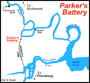
These earthworks are part of the strong Confederate defensive position
known as the "Howlett Line." Composed of a string of interconnected
redoubts and trenches, the line ran eight miles north and south and was
named for the Howlett House which was located on the northern end, near
the site of Battery Dantzler. With batteries housing large caliber guns
anchoring the line on the James River to the north, and the Appomatox
River to the south, the "Howlett Line" defended the eastern approaches
to Richmond between the two rivers. Construction of the "Howlett Line"
began on May 19, 1864, and was ready by June 17, when Parker's "Boy
Company" took up its position here.
The first few weeks along the "Howlett Line" were rather active for the
artillerists. While the Union army shifted its attention south to Petersburg,
the batteries frequently dueled with their Confederate counterparts in this
area. Of particular annoyance to Parker's men was harassing fire coming
from northern sharpshooters concealed in Ware Bottom Church, a small
wooded building located between the lines. One dark evening, three of
Parker's artillerists crawled out to the church and set fire to it, thus
relieving their battery from the deadly fire of the Union riflemen.
|
|

Map of the Howlett Line showing Parker's Battery
Text Under Captain William Parker's photograph
(on the sign above)
Arriving on the "Howlett Line," the "Boy Company" was under the command of
Captain William Watts Parker, the prewar Richmond physician who had raised
the battery two years before. Just weeks before the war's end, Parker was
promoted to Major and left the battery.
|
|

Parker's Battery Earthworks. (E)

Parker's Battery Earthworks. (F)
Photograph taken from inside the Battery.
|
|
PAGE THREE
 >
Civil War Photos
>
Richmond - Outlying Area
>
Parker's Battery
>
Page 2
>
3
>
Civil War Photos
>
Richmond - Outlying Area
>
Parker's Battery
>
Page 2
>
3
|
|


