|
U. S. CIVIL WAR
PHOTOGRAPHS
|

|
CHANCELLORSVILLE
(PAGE 3 OF 8)
| |

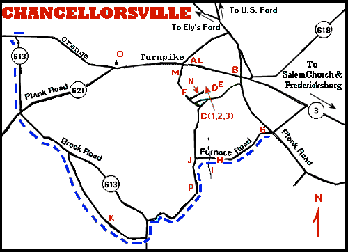
Chancellorsville Map (Described on Page 1)
 (K)
(K)
A stretch of the road that Jackson's troops used in flanking Hooker's
forces.
JACKSON'S FLANK ATTACK
After flanking the Union Line, Jackson's troops attacked east
along the Orange Turnpike, overrunning Howard's Corps as they went.

The star and "You Are Here" indicate
the location of the photographs below.
(Map source: National Park Service)

1999

2005 (Note that the house in the distance is gone!)
The Confederate view to the East towards Chancellorsville. When the
Confederates reached this point, Howard's Corps was in full retreat.
 (O)
(O)
Battle of Chancellorsville--May 2, 3 & 4, 1863 - Union (Gen. Hooker)
Confederate (Gen. Lee). Gen. Jackson mortally wounded.
Lithograph, hand-colored. Kurz & Allison, Art Publishers.
After the successful flanking attack, in the darkness the Confederate
and Union Armies established rough lines to the west of
Chancellorsville. Jackson, determined to block Hooker's army from
withdrawing across the river, rode with his staff between the
Union and Confederate lines in order to determine the best
direction of attack. However, realizing that they
were too close to the Union lines, Jackson and his staff
attempted to return to the Confederate side. The
Confederates, thinking that Jackson and his staff were Union cavalry,
opened fire and Jackson was mortally wounded. A monument, near
the Chancellorsville Visitors Center, marks the location where
Jackson was shot. (For more photographs associated with Jackson's
death, see my
Jackson section.)
 (L)
(L)
Monument indicating where Jackson was shot
|
|
PAGE FOUR
 >
Civil War Photos
>
Chancellorsville
>
Page 2
>
3
>
4
>
5
>
6
>
7
>
8
>
Civil War Photos
>
Chancellorsville
>
Page 2
>
3
>
4
>
5
>
6
>
7
>
8
Notes
|
|


