 |
U. S. CIVIL WAR
PHOTOGRAPHS
|
 |
MINE RUN
(PAGE 2 OF 2)
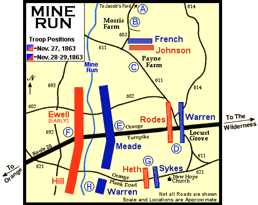
November 27th thru 29th Positions
| |
While French deliberated about which road to take, Confederate Major General
Edward Johnson led his division down the Raccoon Ford Road to connect with
Rodes's left. About 4 p.m. he collided with French's men on the Payne farm.

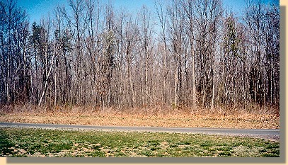
Vicinity of Payne's Farm
Edward Johnson's Confederate Division collided with French's Corps in the
woods and fields in this vicinity. Regardng this photograph, the Stonewall
Brigade (on Johnson's
left) came from behind the cameraman, crossed the road,
and passed through the woods on the opposite side into the open fields of the
Payne farm. (on Johnson's
left) came from behind the cameraman, crossed the road,
and passed through the woods on the opposite side into the open fields of the
Payne farm.
|
Unaware that he faced an entire Union corps, closely supported by a second
(32,000 men total), the aggressive Johnson attacked with his 5,300 veterans.
The heaviest fighting of the campaign occurred as troops charged and
countercharged one another
across the Payne farm fields and through the adjacent woods. Significantly,
Johnson's Southerners halted the Federals and thereby protected Rodes's left
flank at Robertson's Tavern. After dark the
Confederates pulled back to a new position on the high ground west of Mine Run
and constructed strong earthworks.

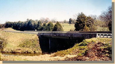
Mine Run - Confederate View.
The modern bridge is for State Route 20 (The Orange Turnpike).
Meade now realized that his plan to steal a march and place his army on Lee's
flank had failed. During the night he concentrated his army on a line
perpendicular to the Turnpike, west of Robertson's Tavern.


Location of the Union Line at Mine Run (Modern State Route 729).
(Photograph is taken from Route 20 approximately one mile east of Mine Run.)
Heavy rains and muddy roads hampered the next day's advance. While Lee's men
strengthened their defenses, Meade plotted his next move.
On the morning of November 29th Meade sent Warren's corps on a wide flanking
maneuver to the south. It took Warren all day to get his men into position  ,
but by 5 p.m. they stood poised to roll up the lightly defended Confederate
right flank. Unfortunately for the Federals, darkness postponed the assault until
morning. During the night, General Lee learned of Warren's movement and
shifted Lieutenant General A.P. Hill's corps to the south, where it hastily
constructed trenches opposite Warren's line. Overnight the temperature dropped
below zero, and without tents, shelters or even fires, the soldiers shivered
through what, for many, was perhaps the worst night of the war. ,
but by 5 p.m. they stood poised to roll up the lightly defended Confederate
right flank. Unfortunately for the Federals, darkness postponed the assault until
morning. During the night, General Lee learned of Warren's movement and
shifted Lieutenant General A.P. Hill's corps to the south, where it hastily
constructed trenches opposite Warren's line. Overnight the temperature dropped
below zero, and without tents, shelters or even fires, the soldiers shivered
through what, for many, was perhaps the worst night of the war.
Meade planned an all-out assault at 6 a.m. on the 30th, but when Warren
informed him that Hill had entrenched across his front and that the movement
could not succeed, Meade suspended the attack. Again the Union commander
pondered his options. Frustrated by Lee's countermove, low on provisions, and
faced with continuing bad weather, he withdrew his army back across the Rapidan
on December 1st.
(Text Source: U.S. Gov't, National Park Service)
|
|
 >
Civil War Photos
>
Mine Run
>
Page 2
>
Civil War Photos
>
Mine Run
>
Page 2