|
U. S. CIVIL WAR
PHOTOGRAPHS
|

|
FREDERICKSBURG

(PAGE 1 OF 8)
OUR VISIT TO FREDERICKSBURG
In the text, the icon  is a link to the definition of the word it marks. is a link to the definition of the word it marks.
Use your browser's "back" button to return to this page.
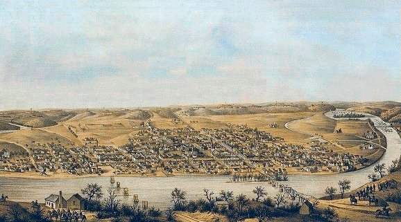
Map (Drawing) of Fredericksburg, November, 1862.
Less than a month before the battle.
| |
Made from the Union side of the Rappahannock River, the map shows the canal, on
the right between the town and the river. Also, in the far distance, is Mayre's
Heights, and, at the bottom of the drawing, Union Soldiers are depicted.
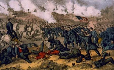
December 11-15, 1862
Estimated Casualties: 17,929 total (US 13,353; CS 4,576)
On November 14, Burnside, now in command of the Army of the Potomac, sent a corps
to occupy the vicinity of Falmouth near
Fredericksburg. The rest of the army soon followed. Lee reacted by entrenching
his army on the heights behind the town. On December 11, Union engineers laid five pontoon bridges across the Rappahannock under
fire. On the 12th, the Federal army crossed over, and on December 13, Burnside
mounted a series of futile frontal assaults on Prospect Hill and Marye's Heights that
resulted in staggering casualties.
On the 13th, in separate attacks, fifteen Union Brigades assaulted the sunken
wall at the foot of Marye's Heights and all were destroyed by the Confederates.
Battle of Fredericksburg, Va. Dec 13th 1862.
Published by Currier & Ives [1862].
Lithograph, hand-colored.
On the Union left flank, Meade's division briefly penetrated Jackson's line but was driven back by a counterattack.
Union generals C. Feger Jackson and George Bayard, and Confederate generals Thomas R. R. Cobb and Maxey Gregg were killed.
On December 15, Burnside called off the offensive and recrossed the river, ending the campaign.
Burnside initiated a new offensive in January 1863, which quickly bogged down in the winter mud. The abortive "Mud March" and other failures led to Burnside's replacement by Maj. Gen. Joseph Hooker in January 1863.
(Text Source: U.S. Gov't, National Park Service)
|
|
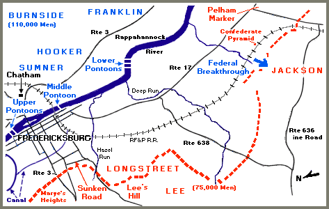
A rather "busy" map of the Fredericksburg Area showing
the location of most of the photographs in this section.
| |
 84
84
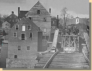
Fredericksburg, 1862
From only one mile away, across the destroyed Rappahannock River bridge, and from a time span of over 138 years, you are looking at Confederate soldiers while they were still serving their nation.
|
|
FREDERICKSBURG - PAGE 2
 >
Civil War Photos
>
Fredericksburg
>
2
>
3
>
4
>
5
>
6
>
7
>
8
>
Civil War Photos
>
Fredericksburg
>
2
>
3
>
4
>
5
>
6
>
7
>
8
Notes
|
|